

Cree modelos digitales a partir de imágenes, con software libre y con Recap En este curso aprenderás a crear e...
Civil 3D Level 3/4 - Civil Works and Land Surveying -AulaGEO
Learn to create basic designs and linear works with Autocad Civil3D software applied to Surveying and Civil Works
Course details
Nivel
:
AutoDesk
Video
:
11 hours
Conferencias
:
6
Certificate of Completion
- Descripción
- FAQ
- Reseñas
Disclaimer:
We have selected this course to offer it in English for its high pedagogical quality and user acceptance.
The version of the software used is in Spanish, but the whole explanation of the instructor is narrated in English.
#AulaGEO
This is the third of a set of 4 courses called “Autocad Civil3D for Surveying and Civil Works” that will allow you to learn how to handle this fabulous Autodesk software and apply it to different projects and construction sites. Become an expert in the software and you can generate earthworks, calculate materials and construction prices and create great designs of roads, bridges, sewerage among others.
This set of courses has been the product of hours of dedication, work and effort, collecting the most important data on the subject of Civil and Topographic Engineering, summarizing large amounts of theory and making them practical, so that you can learn in an easy and easy way. Fast with short but specific classes for each topic and practice with all the (real) data and examples we provide here.
If you want to start managing this software, participating in this course will save you weeks of work by investigating on your own what we have already investigated, doing the tests we have done, and making the mistakes we have already made.
Let us introduce you to this world of Autocad Civil3D, which is a powerful tool to reduce large amounts of time designing and calculating and facilitating your work in the professional field.
Who is it for?
This course is aimed at technicians, technologists and professionals with knowledge in Surveying, civil or related works, who want to start in the world of road design, linear works, earthworks and construction or those who want to strengthen their skills in the management of This powerful tool.
CONTENT OF THE MIDDLE COURSE (3/4)
SURFACES II
– Surface model editing, interpolation, improvements, export.
– Styles of surface models, presentations, map analysis.
– Model overlay.
– Cubing, volume reports between various surfaces.
HORIZONTAL ALIGNMENTS II
– Advanced style management
– Editing and construction of design criteria and tables.
– Graphic, geometric and tabular edition (advanced).
– Parallel axes and over-widths.
– Definition and diagrams of cant.
VERTICAL ALIGNMENTS II
– Construction with design tables.
– Profile overlay.
– Projection of objects from plant to profile.
– Graphic, geometric and tabular edition (advanced).
– Advanced handling of styles, bands.
TYPICAL SECTION II
– Definition of assemblies (structure). Advanced.
– Creation and configuration of sub-assemblies, codes and links.
– Definition of horizontal and vertical transitions
LINEAR WORK II
– Linear work with several alignments.
– Linear work with different regions and structures.
– Advanced edition of linear work, sections, frequency, regions, surfaces.
CROSS SECTIONS II
– Advanced handling of styles, tables, objects to be displayed.
– Editing sampling lines.
– Advanced configuration of materials and prices.
– Mass diagram and reports.
How long do I have access to the course materials?
You can view and review the lecture materials indefinitely, like an on-demand channel.
Can I take my courses with me wherever I go?
Definitely! If you have an internet connection, courses on Udemy are available on any device at any time. If you don't have an internet connection, some instructors also let their students download course lectures. That's up to the instructor though, so make sure you get on their good side!
Estrellas 5
7
Estrellas 4
1
Estrellas 3
2
Estrellas 2
1
Estrellas 1
1
Vertical Alignments II
-
1
 S1 study material
 -
2
 Optimal adjustment alignment
 -
3
Alignment from objects with design standards
-
4
Design rules and checks
-
5
Alignment Composition Tools I
-
6
Alignment Composition Tools II
-
7
Creation of enlargements
-
8
Creación de ensanchamientos automáticos por normas con parale…
-
9
Creation and editing of cant - view of cant
-
10
Insert Horizontal Alignment Labels
Assemblies and subassemblies II
-
11
Study material S2 - Vertical Alignments II
-
12
Creating a simple profile and properties
-
13
Creating a simple profile with lags
-
14
Editing static and dynamic profiles
-
15
Creation and editing of composite profiles (Flush)
-
16
Copy profile and offset (Remove)
-
17
Checks and design standards in profiles
-
18
Profile display style
-
19
Profile shading and labels
-
20
Object projection in profile display
-
21
Profile view division by heights
-
22
Creating multiple profile views
-
23
Creating stacked profile views
-
24
Adding guitars to profile viewing
-
25
Profile Report Creation
Corridor or Linear Work II
-
26
Study material s3 - Assemblies and sub-assemblies II
-
27
Creation of Assemblies and Subassemblies (Review)
-
28
Linear section editor
-
29
Change of assembly and subassembly in a Linear Work
-
30
Conditional Subassemblies
-
31
Examine the conditional assemblies sections
-
32
Create subassembly from polylines
-
33
Subassembly composer
Cross Sections II
-
34
Study material s4 - Linear work II
-
35
Creation of simple linear work (Review)
-
36
Creation of a linear work with transition lane
-
37
Creation of a linear divided road work
-
38
View sections in linear work
-
39
Edit sections of linear work
-
40
Creation of linear work surfaces
-
41
Creation of linear work surface contours
-
42
Comparison of surfaces and linear work path


Este es un curso introductorio a las herramientas de SolidWorks y las técnicas fundamentales de modelado. Le brindará una sólida...

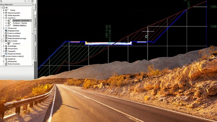
Ensambles, superficies, secciones transversales, cubicación. Aprende a crear diseños y obras lineales básicas con el software Autocad Civil3D aplicado a...