
Creación de modelos BIM para instalaciones de tuberías Lo que aprenderás Trabajar de forma colaborativa en proyectos multi-disciplinarios que involucren...
ArcGIS Pro - Learn easy! - AulaGEO
ArcGIS Pro is the new version of ArcMap
Course details
Nivel
:
Video
:
2 hours
Conferencias
:
1
Certificate of Completion
- Descripción
- FAQ
- Reseñas
-
Course Description:
Learn how to use the tools provided by ArcGIS Pro, starting from scratch.
This course include, the basic of ArcGIS Pro; data edition, methods to selection of spatial data based in attributes and location and creation of bookmarks. Then, we include digitization of shapefiles, addition and digitizing layers, editing attribute and column attributes.
-
What will the user learn?
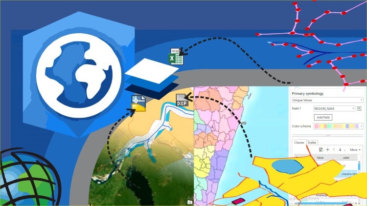
You will learnt to use symbology within features and labeling of points, lines and polygons. Includes buffer analyisis, import of Excel data and georeference of images. #AulaGEO
To share data you will learn how to share data online and generate final maps.
Includes step by step excercises in the AulaGEO environment.
-
This course includes:
The basic with ArcGIS Pro
Clase 1: Let´s start with the ArcGIS Pro
Clase 2: Data selection
Clase 3: Use bookmarks
Creating and editing spatial data
Clase 4: Import data from Excel
Clase 5: Symbology data
Clase 6: Editing of attribute data
Clase 7: Labeling features
Clase 8: Digitization of geographic information
Clase 9: Georeferencing of images
Analysis data
Clase 10: Buffer analysis
Publishing contents from ArcGIS Pro
Clase 11: Map generation
Let´s do it in AulaGEO – step by step excercises
Clase 13: Implications of the change from ArcMap to ArcGIS Pro
Clase 14: Exercise 1. Import CAD data to GIS
Clase 15: Exercise 2. Import coordinates from Excel for split a polygon
Clase 16: Exercise 3. Calculation of areas and composition of calculated fields
Clase 17: Exercise 4. Buffer Analysis
Clase 18: Exercise 5. Attribute labeling
Clase 19: Exercise 6. Thematization by attributes
Clase 20: Exercise 7. Digitization tricks
Clase 21: Exercise 8. Gereferencing images
How long do I have access to the course materials?
You can view and review the lecture materials indefinitely, like an on-demand channel.
Can I take my courses with me wherever I go?
Definitely! If you have an internet connection, courses on Udemy are available on any device at any time. If you don't have an internet connection, some instructors also let their students download course lectures. That's up to the instructor though, so make sure you get on their good side!
Estrellas 5
22
Estrellas 4
19
Estrellas 3
23
Estrellas 2
5
Estrellas 1
3
Creating and editing spatial data
-
1
 Let´s start with the ArcGIS Pro
In this class you will see how to start with the program ArcGIS Pro, from zero.
-Starting ArcGIS Pro
-Login to ArcGIS Pro
-Project Creation
-Changing Base map
-Addition of Vector Data
-
2
Data selection
Learn how to select data with different criterials
-
3
Use bookmarks
In this lesson we will use the bookmark option:
-Creation of Bookmark
-Navigation using bookmark
-Delete Bookmark
Analysis data
-
4
Import data from Excel
In this class you will import data from Excel to the map.
-Import CSV file in ArcGIS Pro to use as SHP file
-
5
Symbology data
In this video you will learn how to add symbology to the spatial data according criterials.
-
6
Editing of attribute data
In this class you will learn how:
-Editing attribute table
-Addition of data calculated from the geometry
-Edit data in different columns
-
7
Labeling features
In this class you will learn:
Labeling of Features; polygons, lines an points, with the choices of rotation and size according the object.
-
8
Digitization of geographic information
In this class you will learn how add and edit spatial data, addition of shapefiles to project and digitizing layers
-
9
Georeferencing of images
In this class, you will learn how to take an image and georeference, define control points, define projection and georeference the image.
Publishing contents from ArcGIS Pro
Advanced features of ArcGIS Pro
Let´s do it in AulaGEO - step by step excercises

Blender 3D Con este curso los estudiantes aprenderán a utilizar todas las herramientas para modelar objetos en 3D, a través...

Te damos la bienvenida al ambiente de Naviworks, herramienta de trabajo colaborativo de Autodesk, diseñado para la gestión de proyectos...