
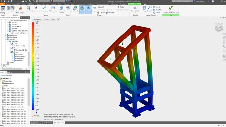
Autodesk Inventor Nastran es un programa de simulación numérico potente y robusto para problemas de ingeniería. Nastran es un motor...
Remote Sensing - fundamentals and applications - AulaGEO
Learn the fundamentals and applications of remote sensing
Course details
Video
:
2 hours
Certificate of Completion
- Descripción
- FAQ
- Reseñas
Remote sensing is the process of detecting and monitoring the physical characteristics of an area by measuring its reflected and emitted radiation at a distance (typically from satellite or aircraft). Special cameras collect remotely sensed images, which help researchers “sense” things about the Earth. Some examples are:
-
Cameras on satellites and airplanes take images of large areas on the Earth’s surface, allowing us to see much more than we can see when standing on the ground.
-
Sonar systems on ships can be used to create images of the ocean floor without needing to travel to the bottom of the ocean.
-
Cameras on satellites can be used to make images of temperature changes in the oceans.
Some specific uses of remotely sensed images of the Earth include:
-
Large forest fires can be mapped from space, allowing rangers to see a much larger area than from the ground.
-
Tracking clouds to help predict the weather or watching erupting volcanoes, and help watching for dust storms.
-
Tracking the growth of a city and changes in farmland or forests over several years or decades.
-
Discovery and mapping of the rugged topography of the ocean floor (e.g., huge mountain ranges, deep canyons, and the “magnetic striping” on the ocean floor). #AulaGEO
Section-1: Introduction
-
Course Introduction
Section-2: Remote Sensing Background
-
Remote Sensing
-
Principle of Remote Sensing
-
Important concepts for Principle of Remote Sensing
-
History of Remote sensing
Section-3: Types of Remote Sensing
-
Sensor based types of Remote Sensing
-
Resolution based types and characteristics of Remote Sensing
-
Purpose based types of Remote Sensing
Section-4: Applications of Remote Sensing data
-
Multispectral Satellite data
-
Microwave (Radar) Satellite da ta
-
Hyperspectral Satellite data
-
Applications in Land Cover
-
Applications in Agriculture
-
Applications in Forestry
-
Applications in Geology
-
Applications in Hydrology
-
Applications in Sea-ice
-
Applications in Oceans and Coastal
How long do I have access to the course materials?
You can view and review the lecture materials indefinitely, like an on-demand channel.
Can I take my courses with me wherever I go?
Definitely! If you have an internet connection, courses on Udemy are available on any device at any time. If you don't have an internet connection, some instructors also let their students download course lectures. That's up to the instructor though, so make sure you get on their good side!
Estrellas 5
27
Estrellas 4
4
Estrellas 3
4
Estrellas 2
1
Estrellas 1
0
Remote Sensing Background
Types of Remote Sensing
Applications of Remote Sensing data

