Search
Geofumadas – GIS – CAD – BIM resources
Menú
Inicio
Blog
Cursos
Plantillas
{{ search }}
login/sign up
kml
Cómo elevar edificios 3D en Google Earth
07
Ago
Posted in:
google Earth / maps
,
Tags:
Google Earth
,
kml
,
Read more
Ver coordenadas UTM en Google Maps y Street View – usando AppScript sobre Google Spreadsheet
09
Jun
2
Posted in:
google Earth / maps
,
Tags:
Google Earth
,
kml
,
Office para mortales
,
Read more
Obtener altitudes de una ruta en Google Earth
13
Abr
1
Posted in:
google Earth / maps
,
Tags:
kml
,
Read more
Como descargar imágenes de Google Earth – Google Maps – Bing – ArcGIS Imagery y otras fuentes
24
Feb
1
Posted in:
Featured
,
google Earth / maps
,
Virtual Earth
,
Tags:
Google Earth
,
kml
,
Read more
Descargar mapas y planear una ruta usando BBBike
16
Dic
Posted in:
google Earth / maps
,
Tags:
Google Earth
,
gps
,
kml
,
Read more
Mi experiencia al utilizar Google Earth para Catastro
03
Dic
1
Posted in:
AutoCAD-AutoDesk
,
Catastro
,
google Earth / maps
,
Tags:
catastro
,
Google Earth
,
kml
,
PlexEarth
,
Read more
Ver coordenadas de Google Earth en Excel – y convertirlas a UTM
26
Nov
5
Posted in:
Descargas
,
google Earth / maps
,
Tags:
Coupons
,
Google Earth
,
kml
,
Read more
Abrir archivos shp con Google Earth
12
Ago
6
Posted in:
geospatial - GIS
,
google Earth / maps
,
Tags:
Google Earth
,
kml
,
QGIS
,
Read more
Spatial Manager: Gestione eficientemente datos espaciales, incluso desde AutoCAD
17
Nov
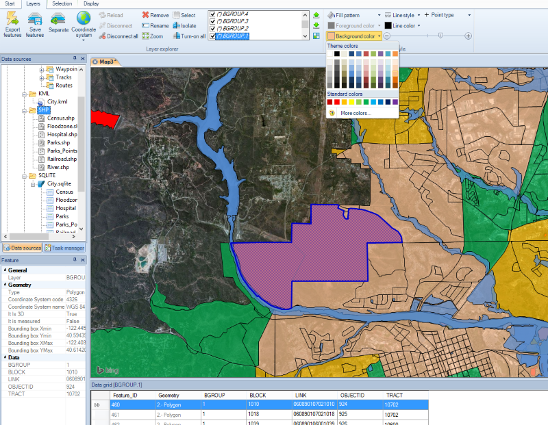
Spatial Manager es una aplicación para la gestión de datos espaciales, que funciona de forma independiente. También tiene un plugin que le da capacidades geoespaciales a AutoCAD.
Posted in:
AutoCAD-AutoDesk
,
geospatial - GIS
,
Tags:
AutoCAD 2015
,
AutoCAD Map
,
dgn
,
dwg
,
kml
,
Mi Primera Impresion
,
QGIS
,
shp
,
Read more
Sincronizar Microstation con Google Earth
01
Abr
Posted in:
Catastro
,
google Earth / maps
,
Microstation-Bentley
,
Tags:
dgn
,
dwg
,
kml
,
Read more
CartoDB, de lo mejor para crear mapas online
23
Dic
2
Posted in:
geospatial - GIS
,
innovaciones
,
Internet y Blogs
,
Tags:
kml
,
shp
,
Read more
OkMap, de lo mejor para crear y editar mapas GPS. GRATUITO
16
Sep
1
Posted in:
google Earth / maps
,
GPS / Equipos
,
Primera Impresión
,
Tags:
Google Earth
,
gps
,
kml
,
shp
,
Read more
SuperGIS Desktop, algunas comparaciones…
05
Mar
1
Posted in:
geospatial - GIS
,
GvSIG
,
SuperGIS
,
Tags:
ESRI
,
gvSIG OS
,
kml
,
Manifold GIS
,
shp
,
Read more
Posify, precisión centimétrica GPS de bajo costo
08
Oct
51
Posted in:
GPS / Equipos
,
Topografia
,
Tags:
kml
,
shp
,
Read more
El Trans 450, Bus de Tránsito Rápido para Tegucigalpa
27
Jun
Posted in:
innovaciones
,
Ordenamiento Territorial
,
Tags:
Google Earth
,
kml
,
Read more
Exportar lista de coordenadas geográficas a Google Earth, desde Excel, con imagen y texto enriquecido
20
Mar
22
Posted in:
Descargas
,
google Earth / maps
,
Tags:
Coupons
,
Google Earth
,
kml
,
Read more
Excel a Google Earth, a partir de coordenadas UTM
22
Feb
114
Posted in:
Descargas
,
Featured
,
google Earth / maps
,
Tags:
Coupons
,
Google Earth
,
kml
,
Read more
Como insertar imágenes locales en Google Earth
14
Dic
6
Posted in:
google Earth / maps
,
Tags:
kml
,
Read more
1
2
3
…
6
Next
Sign In
The password must have a minimum of 8 characters of numbers and letters, contain at least 1 capital letter
I want to sign up as instructor
Recordarme
Sign In
Registro
Restaurar la contraseña
Send reset link
Password reset link sent
to your email
Cerrar
Your application is sent
We'll send you an email as soon as your application is approved.
Go to Profile
No account?
Registro
Sign In
Contraseña perdida